
Make a donation
Gear up for your next adventure:
As an Amazon Associate, this site earns from qualifying purchases at no extra cost to you.
Grândola topographic map
Click on the map to display elevation.
Make a donation
Gear up for your next adventure:
As an Amazon Associate, this site earns from qualifying purchases at no extra cost to you.
Grândola
Significant civic and religious infrastructure was developed after the town's elevation, including the construction of a town hall, a jail, a pillory, a hospital, a Santa Casa da Misericórdia, and several chapels and churches. A common granary was established in 1579 to provide low-interest seed loans to poor farmers, operating until around 1880.
Make a donation
Gear up for your next adventure:
As an Amazon Associate, this site earns from qualifying purchases at no extra cost to you.
About this map
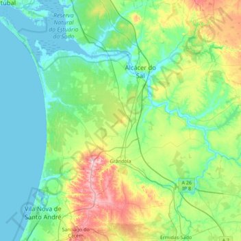
Name: Grândola topographic map, elevation, terrain.
Location: Grândola, Setúbal, Portugal (38.02345 -8.91287 38.50534 -8.23818)
Average elevation: 226 ft
Minimum elevation: -10 ft
Maximum elevation: 1,047 ft
Make a donation
Gear up for your next adventure:
As an Amazon Associate, this site earns from qualifying purchases at no extra cost to you.
Other topographic maps
Click on a map to view its topography, its elevation and its terrain.
Make a donation
Gear up for your next adventure:
As an Amazon Associate, this site earns from qualifying purchases at no extra cost to you.