Geolocate

Gramat topographic map

Click on the map to display elevation.

About this map
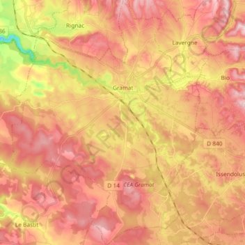
Name: Gramat topographic map, elevation, terrain.

Location: Gramat, Gourdon, Lot, Occitania, Metropolitan France, 46500, France (44.71256 1.65569 44.81582 1.76914)

Average elevation: 1,083 ft

Minimum elevation: 597 ft

Maximum elevation: 1,362 ft

Other topographic maps

Click on a map to view its topography, its elevation and its terrain.
Lostange

France > Occitania > Lot > Linac

Average elevation: 1,070 ft

Mas de la croix

France > Occitania > Lot > Béduer

Average elevation: 928 ft

Pech de Fos

France > Occitania > Lot > Cieurac

Average elevation: 810 ft

Gear up for your next adventure:

🌲Outdoor Survival Books - Best books on survival skills
🪶Wildlife Field Guides - Learn animal tracking and species ID
🎒Waterproof Dry Bags - Keep your electronics and maps dry inside your pack
🧢Outdoor Hiking Hat - Sun protection hat for outdoor explorers
⛺Backpacking Tent - Lightweight and durable tent for multi‑day hikes

As an Amazon Associate, this site earns from qualifying purchases at no extra cost to you.