Geolocate

Porac topographic map

Click on the map to display elevation.

About this map

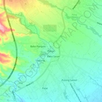
Name: Porac topographic map, elevation, terrain.

Location: Porac, Pampanga, Central Luzon, 2008, Philippines (15.03265 120.50302 15.11265 120.58302)

Average elevation: 299 ft

Minimum elevation: 112 ft

Maximum elevation: 840 ft

Other topographic maps

Click on a map to view its topography, its elevation and its terrain.

San Simon

Philippines > Pampanga

Average elevation: 16 ft

Arayat

Philippines > Pampanga

Average elevation: 128 ft

Candaba

Philippines > Pampanga

Average elevation: 79 ft

San Agustin

Philippines > Pampanga > Candaba

Average elevation: 20 ft

Bahay Pare

Philippines > Pampanga > Candaba

Average elevation: 33 ft

Santo Tomas

Philippines > Pampanga > Santo Tomas

Average elevation: 13 ft

San Esteban

Philippines > Pampanga

Average elevation: 10 ft

Lourdes

Philippines > Pampanga > Candaba

Average elevation: 33 ft

Gear up for your next adventure:

🖼️Topo Map Wall Art - Decorative topographic prints of famous peaks and regions
🦺Reflective Outdoor Gear - Safety gear for low‑light conditions
🪶Thermal Camp Blanket - Extra warmth for cold nights
🧦Hiking Socks - Comfortable socks to prevent blisters on long hikes
🔦Compact Flashlight - Reliable flashlight for emergencies

As an Amazon Associate, this site earns from qualifying purchases at no extra cost to you.