
Thora topographic map
Interactive map
Click on the map to display elevation.
About this map
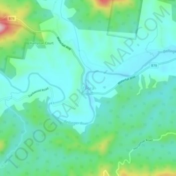
Name: Thora topographic map, elevation, terrain.
Location: Thora, Bellingen Shire Council, New South Wales, Australia (-30.44530 152.76008 -30.40530 152.80008)
Average elevation: 262 ft
Minimum elevation: 56 ft
Maximum elevation: 1,027 ft
Other topographic maps
Click on a map to view its topography, its elevation and its terrain.
Dorrigo National Park
Australia > New South Wales > Thora > Killungoondie Plain
Dorrigo National Park, Thora, Bellingen Shire Council, New South Wales, 2454, Australia
Average elevation: 1,512 ft