
Make a donation
Gear up for your next adventure:
As an Amazon Associate, this site earns from qualifying purchases at no extra cost to you.
Nitra topographic map
Click on the map to display elevation.
Make a donation
Gear up for your next adventure:
As an Amazon Associate, this site earns from qualifying purchases at no extra cost to you.
Nitra
Nitra lies at an altitude of 190 metres (623 ft) above sea level and covers an area of 100.48 square kilometres (38.8 sq mi). It is located in the Nitra River valley in the Danubian Lowland, where the bigger part of the city is located. A smaller part is located at the southernmost reaches of the Tribeč mountains, more precisely at the foothill of the Zobor mountain 587 metres (1,926 ft). It is around halfway between Slovak capital Bratislava, 92 kilometres (57 mi) away and central Slovak city of Banská Bystrica, 118 kilometres (73 mi) away. Other towns in the surroundings include Trnava to the west (53 km), Topoľčany to the north (35 km), Levice to the east (42 km), and Nové Zámky (37 km) and Komárno (71 km) to the south. A national natural reservation called Zoborská lesostep is located within the city's boundaries.
Make a donation
Gear up for your next adventure:
As an Amazon Associate, this site earns from qualifying purchases at no extra cost to you.
About this map
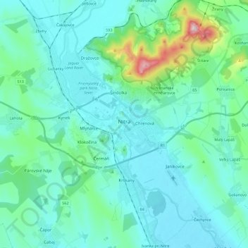
Name: Nitra topographic map, elevation, terrain.
Average elevation: 646 ft
Minimum elevation: 423 ft
Maximum elevation: 1,982 ft
Make a donation
Gear up for your next adventure:
As an Amazon Associate, this site earns from qualifying purchases at no extra cost to you.
Other topographic maps
Click on a map to view its topography, its elevation and its terrain.