
Make a donation
Gear up for your next adventure:
As an Amazon Associate, this site earns from qualifying purchases at no extra cost to you.
Kenilworth topographic map
Click on the map to display elevation.
Make a donation
Gear up for your next adventure:
As an Amazon Associate, this site earns from qualifying purchases at no extra cost to you.
About this map
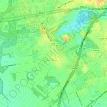
Name: Kenilworth topographic map, elevation, terrain.
Location: Kenilworth, Union County, New Jersey, 07033, United States (40.66519 -74.31317 40.69110 -74.26935)
Average elevation: 92 ft
Minimum elevation: 46 ft
Maximum elevation: 141 ft
Union County trails, hiking, mountain biking, running and outdoor activities
Make a donation
Gear up for your next adventure:
As an Amazon Associate, this site earns from qualifying purchases at no extra cost to you.
Other topographic maps
Click on a map to view its topography, its elevation and its terrain.
Make a donation
Gear up for your next adventure:
As an Amazon Associate, this site earns from qualifying purchases at no extra cost to you.
Staten Island Junction
United States > New Jersey > Union County > Cranford > Staten Island Junction
Average elevation: 79 ft
Make a donation
Gear up for your next adventure:
As an Amazon Associate, this site earns from qualifying purchases at no extra cost to you.