
Lampung topographic map
Interactive map
Click on the map to display elevation.
About this map
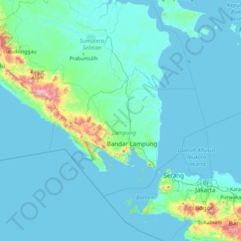
Name: Lampung topographic map, elevation, terrain.
Location: Lampung, Indonesien (-7.41550 102.46730 -2.29550 107.58730)
Average elevation: 325 ft
Minimum elevation: -7 ft
Maximum elevation: 9,419 ft
Other topographic maps
Click on a map to view its topography, its elevation and its terrain.
Tanjung Raya
Indonesien > Lampung > Tanjung Raya
Tanjung Raya, Lampung, 35119, Indonesien
Average elevation: 262 ft
PEMANDIAN WAY KUWOL
PEMANDIAN WAY KUWOL, Lampung, Indonesien
Average elevation: 2,539 ft
Rajabasa
Indonesien > Lampung > Bandar Lampung
Rajabasa, Bandar Lampung, Lampung, Indonesien
Average elevation: 3,143 ft
Sekincau Belirang
Sekincau Belirang, Lampung, Indonesien
Average elevation: 4,150 ft