
Roxburgh topographic map
Interactive map
Click on the map to display elevation.
About this map
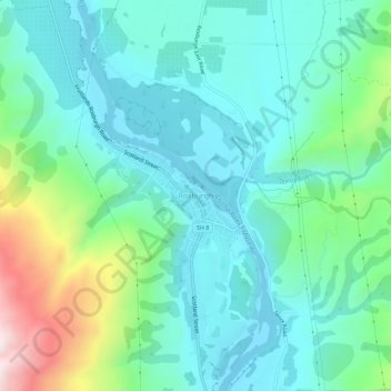
Name: Roxburgh topographic map, elevation, terrain.
Average elevation: 732 ft
Minimum elevation: 243 ft
Maximum elevation: 2,362 ft
Other topographic maps
Click on a map to view its topography, its elevation and its terrain.
Shingle Creek
New Zealand > Otago > Central Otago District > Teviot Valley Community
Shingle Creek, Teviot Valley Community, Central Otago District, Otago, New Zealand
Average elevation: 1,007 ft
Millers Flat
New Zealand > Otago > Central Otago District > Teviot Valley Community
Millers Flat, Teviot Valley Community, Central Otago District, Otago, 9572, New Zealand
Average elevation: 528 ft