
Thank you for supporting this site ❤️
Make a donation
Make a donation
Gear up for your next adventure:
As an Amazon Associate, this site earns from qualifying purchases at no extra cost to you.
Cangas topographic map
Click on the map to display elevation.
Thank you for supporting this site ❤️
Make a donation
Make a donation
Gear up for your next adventure:
As an Amazon Associate, this site earns from qualifying purchases at no extra cost to you.
About this map
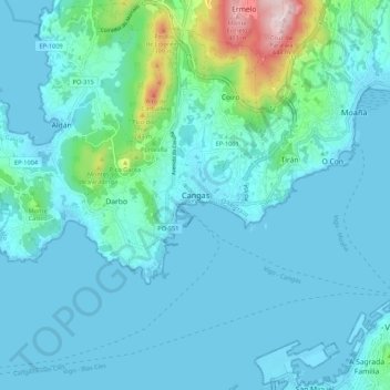
Name: Cangas topographic map, elevation, terrain.
Location: Cangas, O Morrazo, Pontevedra, Galicia, 36940, Spain (42.22472 -8.81965 42.30472 -8.73965)
Average elevation: 177 ft
Minimum elevation: -3 ft
Maximum elevation: 1,430 ft
Thank you for supporting this site ❤️
Make a donation
Make a donation
Gear up for your next adventure:
As an Amazon Associate, this site earns from qualifying purchases at no extra cost to you.