
Belmont Regional Park topographic map
Interactive map
Click on the map to display elevation.
About this map
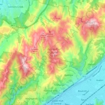
Name: Belmont Regional Park topographic map, elevation, terrain.
Average elevation: 610 ft
Minimum elevation: 7 ft
Maximum elevation: 1,463 ft
Other topographic maps
Click on a map to view its topography, its elevation and its terrain.
Judgeford
New Zealand > Wellington > Porirua City > Porirua
Judgeford, Porirua, Porirua City, Wellington, New Zealand
Average elevation: 558 ft
Colonial Knob
New Zealand > Wellington > Porirua City > Porirua
Colonial Knob, Porirua, Porirua City, Wellington, 5028, New Zealand
Average elevation: 902 ft