
Make a donation
Gear up for your next adventure:
As an Amazon Associate, this site earns from qualifying purchases at no extra cost to you.
Municipio de Humahuaca topographic map
Click on the map to display elevation.
Make a donation
Gear up for your next adventure:
As an Amazon Associate, this site earns from qualifying purchases at no extra cost to you.
Municipio de Humahuaca
Humahuaca has a cool arid climate (Köppen BWk), with two seasons: a mild summer with occasional thunderstorms from December to March, and a cool, extremely clear, rainless winter covering the rest of the year. Although afternoons are warm year-round, the extreme altitude means mornings are cool in summer and freezing in the rainless, cloudless winter.
Make a donation
Gear up for your next adventure:
As an Amazon Associate, this site earns from qualifying purchases at no extra cost to you.
About this map
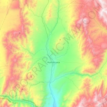
Name: Municipio de Humahuaca topographic map, elevation, terrain.
Average elevation: 11,969 ft
Minimum elevation: 9,049 ft
Maximum elevation: 15,951 ft
Make a donation
Gear up for your next adventure:
As an Amazon Associate, this site earns from qualifying purchases at no extra cost to you.
Other topographic maps
Click on a map to view its topography, its elevation and its terrain.