Geolocate

Northfield topographic map

Click on the map to display elevation.

About this map

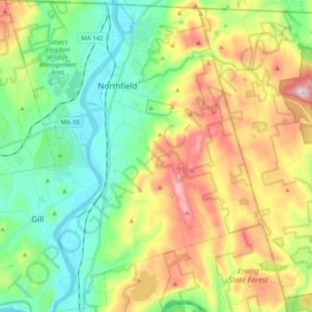
Name: Northfield topographic map, elevation, terrain.

Location: Northfield, Franklin County, Massachusetts, 01360, United States (42.60401 -72.51677 42.72860 -72.37712)

Average elevation: 682 ft

Minimum elevation: 164 ft

Maximum elevation: 1,604 ft

Franklin County trails, hiking, mountain biking, running and outdoor activities

Other topographic maps

Click on a map to view its topography, its elevation and its terrain.

Fort Lucas

United States > Massachusetts > Franklin County

Average elevation: 876 ft

Mount Hermon

United States > Massachusetts > Franklin County > Gill

Average elevation: 325 ft

Mount Ram

United States > Massachusetts > Franklin County

Average elevation: 577 ft

Pitt Hill

United States > Massachusetts > Franklin County > Orange

Average elevation: 955 ft

Shelburne

United States > Massachusetts > Franklin County

Average elevation: 873 ft

Mount Hermon

United States > Massachusetts > Franklin County > Gill

Average elevation: 325 ft

Gear up for your next adventure:

🏫Relief Map Kits - Hands-on tools for teaching landforms and elevation
🪶Trail Camera - Capture wildlife on your hikes
😴Insulated Sleeping Pads - Compact and warm pads for high-elevation camping
🧭Outdoor Navigation Book - Learn advanced navigation skills
🎒Hydration Pack - Hands‑free water reservoir for long hikes

As an Amazon Associate, this site earns from qualifying purchases at no extra cost to you.