
中卫市 topographic map
Interactive map
Click on the map to display elevation.
About this map
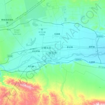
Name: 中卫市 topographic map, elevation, terrain.
Location: 中卫市, 文昌镇, 沙坡头区, 中卫市, 宁夏回族自治区, 755000, 中国 (37.33999 105.03288 37.65999 105.35288)
Average elevation: 4,400 ft
Minimum elevation: 3,944 ft
Maximum elevation: 6,503 ft
中卫市位于宁夏回族自治区中西部,宁、甘、蒙三省区交汇处,是黄河中上游第一个自流灌溉市。地势西南高,东北低,市区平均海拔1225米,地貌类型分为黄河冲积平原、台地、沙漠、山地与丘陵五大单元。