
Make a donation
Gear up for your next adventure:
As an Amazon Associate, this site earns from qualifying purchases at no extra cost to you.
Ujjain topographic map
Click on the map to display elevation.
Make a donation
Gear up for your next adventure:
As an Amazon Associate, this site earns from qualifying purchases at no extra cost to you.
Ujjain
Ujjain is located in the west-central part of India, and is north of the upper limit of the Vindhya mountain ranges. Located on the Malwa plateau, it is higher than the north Indian plains and the land rises towards the Vindhya Range to the south. Ujjain's coordinates are 23°10′N 75°46′E / 23.167°N 75.767°E / 23.167; 75.767 with an average elevation of 494 m (1620 ft). The region is an extension of the Deccan Traps, formed between 60 and 68 million years ago at the end of the Cretaceous period. The city is on the bank of the river Shipra which flows into the nearby Chambal.
Make a donation
Gear up for your next adventure:
As an Amazon Associate, this site earns from qualifying purchases at no extra cost to you.
About this map
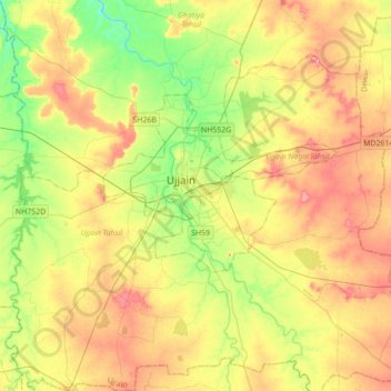
Name: Ujjain topographic map, elevation, terrain.
Average elevation: 1,644 ft
Minimum elevation: 1,503 ft
Maximum elevation: 1,795 ft
Make a donation
Gear up for your next adventure:
As an Amazon Associate, this site earns from qualifying purchases at no extra cost to you.