
Hodge Hill topographic map
Interactive map
Click on the map to display elevation.
About this map
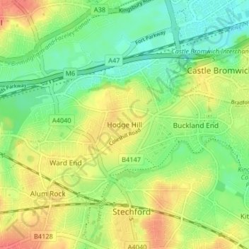
Name: Hodge Hill topographic map, elevation, terrain.
Average elevation: 331 ft
Minimum elevation: 253 ft
Maximum elevation: 423 ft
Other topographic maps
Click on a map to view its topography, its elevation and its terrain.
Aston
United Kingdom > England > Birmingham
Aston, Birmingham, West Midlands Combined Authority, England, B6 5PL, United Kingdom
Average elevation: 394 ft
Nechells
United Kingdom > England > Birmingham
Nechells, Birmingham, West Midlands Combined Authority, England, B7 5QU, United Kingdom
Average elevation: 344 ft
Hall Green
United Kingdom > England > Birmingham
Hall Green, Birmingham, West Midlands Combined Authority, England, B28 9DG, United Kingdom
Average elevation: 443 ft
Perry Beeches
United Kingdom > England > Birmingham
Perry Beeches, Birmingham, West Midlands Combined Authority, England, B42 2HY, United Kingdom
Average elevation: 420 ft
Sparkhill
United Kingdom > England > Birmingham
Sparkhill, Birmingham, West Midlands Combined Authority, England, B11 4LL, United Kingdom
Average elevation: 423 ft
Attwood Green
United Kingdom > England > Birmingham
Attwood Green, Birmingham, West Midlands Combined Authority, England, B15 2AR, United Kingdom
Average elevation: 430 ft
Sutton Coldfield
United Kingdom > England > Birmingham
Sutton Coldfield, Birmingham, West Midlands Combined Authority, England, United Kingdom
Average elevation: 407 ft
Warwickshire
United Kingdom > England > Birmingham
Warwickshire, Pencroft Road, Castle Vale, Birmingham, West Midlands Combined Authority, West Midlands, England, B34, United Kingdom
Average elevation: 364 ft