
La Barberine topographic map
Interactive map
Click on the map to display elevation.
About this map
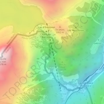
Name: La Barberine topographic map, elevation, terrain.
Location: La Barberine, Finhaut, Saint-Maurice, Vallese, 1925, Svizzera (46.05983 6.93710 46.06128 6.93771)
Average elevation: 5,600 ft
Minimum elevation: 3,642 ft
Maximum elevation: 8,360 ft
Other topographic maps
Click on a map to view its topography, its elevation and its terrain.
Lac d'Émosson
Lac d'Émosson, Galerie d'accès du Chatelard, Le Châtelaret, Finhaut, Saint-Maurice, Vallese, 1925, Svizzera
Average elevation: 7,349 ft