
Make a donation
Gear up for your next adventure:
As an Amazon Associate, this site earns from qualifying purchases at no extra cost to you.
Pedanía Parroquia topographic map
Click on the map to display elevation.
Make a donation
Gear up for your next adventure:
As an Amazon Associate, this site earns from qualifying purchases at no extra cost to you.
About this map
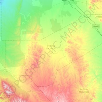
Name: Pedanía Parroquia topographic map, elevation, terrain.
Average elevation: 2,890 ft
Minimum elevation: 1,801 ft
Maximum elevation: 4,524 ft
Make a donation
Gear up for your next adventure:
As an Amazon Associate, this site earns from qualifying purchases at no extra cost to you.
Other topographic maps
Click on a map to view its topography, its elevation and its terrain.
Cordoba
Argentina > Córdoba > Pedanía Capital
The wealthier suburbs west of the city are located at slightly higher altitudes, which allows cool breezes to blow in the summer, bringing drier, comfortable nights during hotter periods, and more regular frost in the winter. Generally speaking, Córdoba's daytime temperatures are very slightly warmer than…
Average elevation: 1,499 ft
Observatorio Las Punillas
Argentina > Córdoba > Pedanía Alta Gracia > Alta Gracia
Average elevation: 1,857 ft
Make a donation
Gear up for your next adventure:
As an Amazon Associate, this site earns from qualifying purchases at no extra cost to you.
Make a donation
Gear up for your next adventure:
As an Amazon Associate, this site earns from qualifying purchases at no extra cost to you.
Make a donation
Gear up for your next adventure:
As an Amazon Associate, this site earns from qualifying purchases at no extra cost to you.
Falda del Carmen
Argentina > Córdoba > Pedanía Lagunilla > Falda del Carmen
Average elevation: 2,172 ft