
l'Éperon topographic map
Interactive map
Click on the map to display elevation.
About this map
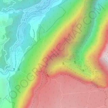
Name: l'Éperon topographic map, elevation, terrain.
Location: l'Éperon, Salazie, Saint-Benoît, La Réunion, 97433, France (-21.03615 55.54748 -21.03605 55.54758)
Average elevation: 3,074 ft
Minimum elevation: 1,273 ft
Maximum elevation: 5,075 ft
Other topographic maps
Click on a map to view its topography, its elevation and its terrain.
Piton des Neiges
France > La Réunion > Salazie
Piton des Neiges, Salazie, Saint-Benoît, La Réunion, 97433, France
Average elevation: 8,091 ft
Réserve biologique dirigée de Bébour
France > La Réunion > Salazie
Réserve biologique dirigée de Bébour, Route Forestière de Bébour-Bélouve, Trou Blanc, Salazie, Saint-Benoît, La Réunion, 97433, France
Average elevation: 5,240 ft
Coteau Monique
France > La Réunion > Salazie
Coteau Monique, Sentier de l'Ecole Normale, Trou Blanc, Salazie, Saint-Benoît, La Réunion, 97433, France
Average elevation: 5,203 ft
Trou de Fer
France > La Réunion > Salazie
Trou de Fer, Salazie, Saint-Benoît, La Réunion, 97433, France
Average elevation: 3,766 ft