
Matagalpa topographic map
Interactive map
Click on the map to display elevation.
About this map
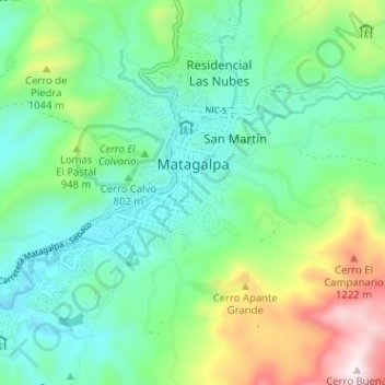
Name: Matagalpa topographic map, elevation, terrain.
Average elevation: 2,812 ft
Minimum elevation: 2,073 ft
Maximum elevation: 4,705 ft
Matagalpa ist die Hauptstadt des Departamentos Matagalpa, mit 485.500 Einwohnern der zweitgrößte Verwaltungsbezirk in Nicaragua. Das Municipio Matagalpa zählt etwa 200.000 Einwohner. Davon leben circa 120.000 in der Stadt und etwa 80.000 im Umland. Matagalpa liegt in einer Höhe von 681 Metern über dem Meeresspiegel.
Other topographic maps
Click on a map to view its topography, its elevation and its terrain.
Esquipulas (Municipio)
Esquipulas (Municipio), Matagalpa, 62500, Nicaragua
Average elevation: 1,916 ft