
Karsdorf topographic map
Interactive map
Click on the map to display elevation.
About this map
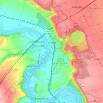
Name: Karsdorf topographic map, elevation, terrain.
Average elevation: 558 ft
Minimum elevation: 354 ft
Maximum elevation: 784 ft
Other topographic maps
Click on a map to view its topography, its elevation and its terrain.
Thierbach
Duitsland > Saksen-Anhalt > Burgenlandkreis
Thierbach, Meineweh, Wethautal, Burgenlandkreis, Saksen-Anhalt, 06721, Duitsland
Average elevation: 902 ft
Bad Bibra
Duitsland > Saksen-Anhalt > Burgenlandkreis
Bad Bibra, An der Finne, Burgenlandkreis, Saksen-Anhalt, Duitsland
Average elevation: 755 ft
Osterfeld
Duitsland > Saksen-Anhalt > Burgenlandkreis > Osterfeld > Osterfeld
Osterfeld, Wethautal, Burgenlandkreis, Saksen-Anhalt, 06721, Duitsland
Average elevation: 781 ft