
Granville topographic map
Interactive map
Click on the map to display elevation.
About this map
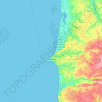
Name: Granville topographic map, elevation, terrain.
Average elevation: 82 ft
Minimum elevation: 0 ft
Maximum elevation: 449 ft
Other topographic maps
Click on a map to view its topography, its elevation and its terrain.
Chevry
França > Normandia > Manche > Moyon Villages
Chevry, Moyon Villages, Saint-Lô, Manche, Normandia, França metropolitana, 50420, França
Average elevation: 338 ft
Saint-Barthélemy
Saint-Barthélemy, Avranches, Manche, Normandia, França metropolitana, 50140, França
Average elevation: 846 ft
Bas Courtils
França > Normandia > Manche > Courtils > Bas Courtils
Bas Courtils, Courtils, Avranches, Manche, Normandia, França metropolitana, 50220, França
Average elevation: 20 ft