
Moinabad topographic map
Interactive map
Click on the map to display elevation.
About this map
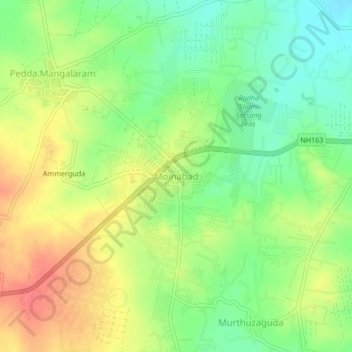
Name: Moinabad topographic map, elevation, terrain.
Average elevation: 1,890 ft
Minimum elevation: 1,791 ft
Maximum elevation: 2,005 ft
Other topographic maps
Click on a map to view its topography, its elevation and its terrain.
Himayat Sagar
India > Telangana > Moinabad mandal > Nagireddyguda
Himayat Sagar, Nagireddyguda, Moinabad mandal, Ranga Reddy District, Telangana, 500058, India
Average elevation: 1,778 ft
Chilkur
India > Telangana > Moinabad mandal
Chilkur, Moinabad mandal, Ranga Reddy District, Telangana, 501504, India
Average elevation: 1,824 ft