
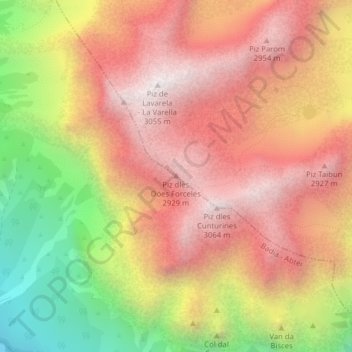
Piz dles Döes Forceles topographic map
Interactive map
Click on the map to display elevation.
About this map
Name: Piz dles Döes Forceles topographic map, elevation, terrain.
Average elevation: 8,146 ft
Minimum elevation: 5,525 ft
Maximum elevation: 9,957 ft
Other topographic maps
Click on a map to view its topography, its elevation and its terrain.
Ciaminades
Italy > Trentino-Alto Adige/Südtirol > South Tyrol > Badia - Abtei
Ciaminades, Badia - Abtei, Pustertal - Val Pusteria, South Tyrol, Trentino-Alto Adige/Südtirol, 39036, Italy
Average elevation: 5,361 ft
Rüdeferia
Italy > Trentino-Alto Adige/Südtirol > South Tyrol > Badia - Abtei
Rüdeferia, Badia - Abtei, Pustertal - Val Pusteria, South Tyrol, Trentino-Alto Adige/Südtirol, 39036, Italy
Average elevation: 5,709 ft