
Ehingen (Donau) topographic map
Interactive map
Click on the map to display elevation.
About this map
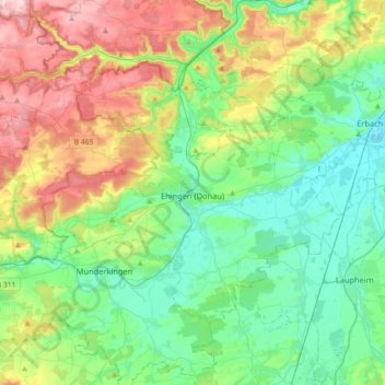
Name: Ehingen (Donau) topographic map, elevation, terrain.
Average elevation: 1,906 ft
Minimum elevation: 1,558 ft
Maximum elevation: 2,687 ft
Other topographic maps
Click on a map to view its topography, its elevation and its terrain.
73340
Allemagne > Bade-Wurtemberg > Alb-Donau-Kreis > Hofstett-Emerbuch > Benzwang
73340, Benzwang, Hofstett-Emerbuch, Amstetten, Gemeindeverwaltungsverband Lonsee-Amstetten, Alb-Donau-Kreis, Bade-Wurtemberg, Allemagne
Average elevation: 2,113 ft
Kirchbierlingen
Allemagne > Bade-Wurtemberg > Alb-Donau-Kreis > Ehingen (Donau)
Kirchbierlingen, Ehingen (Donau), Gemeindeverwaltungsverband Ehingen (Donau), Alb-Donau-Kreis, Bade-Wurtemberg, 89616, Allemagne
Average elevation: 1,686 ft
Altheim
Allemagne > Bade-Wurtemberg > Alb-Donau-Kreis
Altheim, Gemeindeverwaltungsverband Allmendingen, Alb-Donau-Kreis, Bade-Wurtemberg, 89605, Allemagne
Average elevation: 1,942 ft