
Grand Teton National Park topographic map
Interactive map
Click on the map to display elevation.
About this map
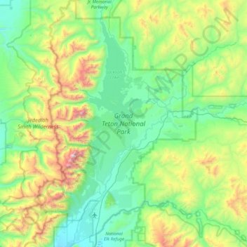
Name: Grand Teton National Park topographic map, elevation, terrain.
Average elevation: 7,904 ft
Minimum elevation: 6,211 ft
Maximum elevation: 13,507 ft
Grand Teton National Park is named for Grand Teton, the tallest mountain in the Teton Range. The naming of the mountains is attributed to early 19th-century French-speaking trappers—les trois tétons (the three teats) was later anglicized and shortened to Tetons. At 13,775 feet (4,199 m), Grand Teton abruptly rises more than 7,000 feet (2,100 m) above Jackson Hole, almost 850 feet (260 m) higher than Mount Owen, the second-highest summit in the range. The park has numerous lakes, including 15-mile-long (24 km) Jackson Lake as well as streams of varying length and the upper main stem of the Snake River. Though in a state of recession, a dozen small glaciers persist at the higher elevations near the highest peaks in the range. Some of the rocks in the park are the oldest found in any American national park and have been dated at nearly 2.7 billion years.
Other topographic maps
Click on a map to view its topography, its elevation and its terrain.
Rocky Mountains
United States > Wyoming > Teton County
Rocky Mountains, Teton County, Wyoming, United States
Average elevation: 7,520 ft
Buck Mountain
United States > Wyoming > Teton County
Buck Mountain, Teton County, Wyoming, United States
Average elevation: 10,262 ft
Jenny Lake
United States > Wyoming > Teton County
Jenny Lake, Teton County, Wyoming, United States
Average elevation: 6,919 ft
Delusion Lake
United States > Wyoming > Teton County
Delusion Lake, Teton County, Wyoming, United States
Average elevation: 7,867 ft
South Park
United States > Wyoming > Teton County > Rafter J Ranch
South Park, Rafter J Ranch, Teton County, Wyoming, United States
Average elevation: 6,325 ft
Heart Lake
United States > Wyoming > Teton County
Heart Lake, Teton County, Wyoming, United States
Average elevation: 7,549 ft
Wilson
United States > Wyoming > Teton County > Wilson
Wilson, Teton County, Wyoming, United States
Average elevation: 7,244 ft
Rendezvous Mountain
United States > Wyoming > Teton County > Teton Village
Rendezvous Mountain, Teton Village, Teton County, Wyoming, 83025, United States
Average elevation: 9,281 ft
Jackson
United States > Wyoming > Teton County
Jackson, Teton County, Wyoming, 83002, United States
Average elevation: 6,703 ft
Grand Teton
United States > Wyoming > Teton County
Grand Teton, Teton County, Wyoming, United States
Average elevation: 10,925 ft
Teton Village
United States > Wyoming > Teton County
Teton Village, Teton County, Wyoming, 83025, United States
Average elevation: 7,621 ft
Bobcat Ridge
United States > Wyoming > Teton County
Bobcat Ridge, Teton County, Wyoming, United States
Average elevation: 9,032 ft
Moose
United States > Wyoming > Teton County
Moose, Teton County, Wyoming, United States
Average elevation: 6,598 ft
Upper Geyser Basin
United States > Wyoming > Teton County
Upper Geyser Basin, Teton County, Wyoming, United States
Average elevation: 7,530 ft
Mount Moran
United States > Wyoming > Teton County
Mount Moran, Teton County, Wyoming, United States
Average elevation: 10,138 ft
Yellowstone Caldera Supervolcano
United States > Wyoming > Teton County
Yellowstone Caldera Supervolcano, Teton County, Wyoming, United States
Average elevation: 8,301 ft
Beaver Creek
United States > Wyoming > Teton County
Beaver Creek, Teton County, Wyoming, 83012, United States
Average elevation: 6,703 ft
Yellowstone Lake
United States > Wyoming > Teton County
Yellowstone Lake, Teton County, Wyoming, United States
Average elevation: 8,048 ft
Jackson Lake
United States > Wyoming > Teton County
Jackson Lake, Teton County, Wyoming, United States
Average elevation: 7,707 ft
Grant Village
United States > Wyoming > Teton County
Grant Village, Teton County, Wyoming, United States
Average elevation: 7,844 ft