
Wilson topographic map
Click on the map to display elevation.
Wilson
Wilson is located at 43°29′11″N 110°52′45″W / 43.48639°N 110.87917°W / 43.48639; -110.87917 (43.4863, -110.8793). at an elevation of 6,148 feet (1,874 m) above sea level.
About this map
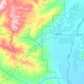
Name: Wilson topographic map, elevation, terrain.
Location: Wilson, Teton County, Wyoming, United States (43.43461 -110.95763 43.54284 -110.83970)
Average elevation: 7,244 ft
Minimum elevation: 6,056 ft
Maximum elevation: 10,226 ft
Teton County trails, hiking, mountain biking, running and outdoor activities