
Sheridan Township topographic map
Interactive map
Click on the map to display elevation.
About this map
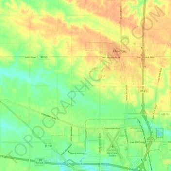
Name: Sheridan Township topographic map, elevation, terrain.
Location: Sheridan Township, Scott County, Iowa, 52748, United States (41.59626 -90.66655 41.68409 -90.54887)
Average elevation: 758 ft
Minimum elevation: 692 ft
Maximum elevation: 814 ft
Other topographic maps
Click on a map to view its topography, its elevation and its terrain.
Davenport
United States > Iowa > Scott County
Davenport, Scott County, Iowa, United States
Average elevation: 673 ft
Park View
United States > Iowa > Scott County
Park View, Scott County, Iowa, United States
Average elevation: 771 ft
Buffalo
United States > Iowa > Scott County
Buffalo, Buffalo Township, Scott County, Iowa, 52728, United States
Average elevation: 673 ft
Bettendorf
United States > Iowa > Scott County > Pleasant Valley Township
Bettendorf, Pleasant Valley Township, Scott County, Iowa, 52722, United States
Average elevation: 679 ft
Pleasant Valley Township
United States > Iowa > Scott County
Pleasant Valley Township, Scott County, Iowa, United States
Average elevation: 650 ft
Le Claire
United States > Iowa > Scott County
Le Claire, Le Claire Township, Scott County, Iowa, United States
Average elevation: 656 ft
Walcott
United States > Iowa > Scott County > Walcott
Walcott, Blue Grass Township, Scott County, Iowa, United States
Average elevation: 745 ft
Eldridge
United States > Iowa > Scott County
Eldridge, Sheridan Township, Scott County, Iowa, 52748, United States
Average elevation: 768 ft
Davenport
United States > Iowa > Scott County > Davenport
Davenport, Scott County, Iowa, 52801, United States
Average elevation: 696 ft
Blue Grass
United States > Iowa > Scott County
Blue Grass, Blue Grass Township, Scott County, Iowa, United States
Average elevation: 784 ft
Long Grove
United States > Iowa > Scott County
Long Grove, Scott County, Iowa, United States
Average elevation: 771 ft