
Algeciras topographic map
Interactive map
Click on the map to display elevation.
About this map
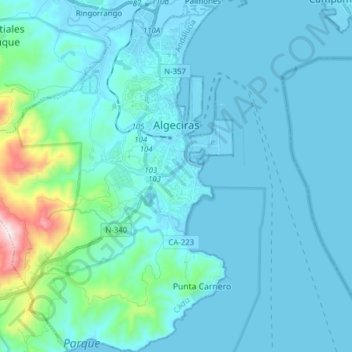
Name: Algeciras topographic map, elevation, terrain.
Location: Algeciras, Campo de Gibraltar, Cadix, Andalousie, Espagne (36.05020 -5.55110 36.17549 -5.42230)
Average elevation: 253 ft
Minimum elevation: -23 ft
Maximum elevation: 2,516 ft
Other topographic maps
Click on a map to view its topography, its elevation and its terrain.
El Pelayo
Espagne > Andalousie > Campo de Gibraltar > Algésiras
El Pelayo, Algésiras, Campo de Gibraltar, Cadix, Andalousie, 11206, Espagne
Average elevation: 968 ft
San Roque
Espagne > Andalousie > Campo de Gibraltar
San Roque, Campo de Gibraltar, Cadix, Andalousie, Espagne
Average elevation: 233 ft
Facinas
Espagne > Andalousie > Campo de Gibraltar > Tarifa
Facinas, Tarifa, Campo de Gibraltar, Cadix, Andalousie, 11380, Espagne
Average elevation: 374 ft