
Daïra Guelma topographic map
Interactive map
Click on the map to display elevation.
About this map
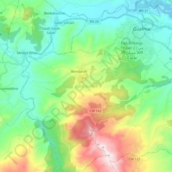
Name: Daïra Guelma topographic map, elevation, terrain.
Location: Daïra Guelma, Guelma, Algérie (36.34605 7.30585 36.48888 7.47259)
Average elevation: 1,752 ft
Minimum elevation: 591 ft
Maximum elevation: 4,593 ft
Other topographic maps
Click on a map to view its topography, its elevation and its terrain.
Guelma
Algérie > Guelma > Daïra Guelma
Guelma, Daïra Guelma, Guelma, Algérie
Average elevation: 1,145 ft