Geolocate

Mulbarton topographic map

Click on the map to display elevation.

About this map

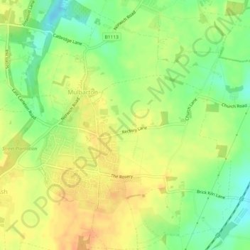
Name: Mulbarton topographic map, elevation, terrain.

Location: Mulbarton, South Norfolk, Norfolk, England, United Kingdom (52.54658 1.22306 52.57439 1.26183)

Average elevation: 135 ft

Minimum elevation: 69 ft

Maximum elevation: 180 ft

Other topographic maps

Click on a map to view its topography, its elevation and its terrain.

Keswick

United Kingdom > England > Norfolk > South Norfolk

Average elevation: 75 ft

Gear up for your next adventure:

🔭Telescopic Hiking Pole - Adjustable pole for hiking stability
🪶Survival Guide Book - Expert advice for emergency preparedness
🗺️NatGeo Topo Maps - High-quality waterproof printed topographic maps of US Parks
🔭Compact Binoculars - HD vision for scouting terrain and identifying distant landmarks
⛑️Personal Locator Beacon - Safety beacon for emergencies

As an Amazon Associate, this site earns from qualifying purchases at no extra cost to you.