Geolocate

Ephraim topographic map

Click on the map to display elevation.

About this map

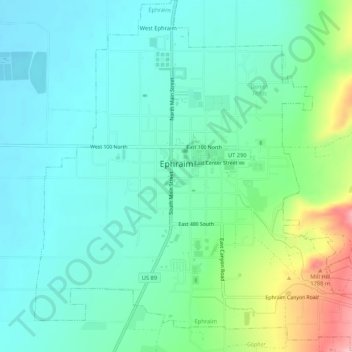
Name: Ephraim topographic map, elevation, terrain.

Location: Ephraim, Sanpete County, Utah, 84627, United States (39.33764 -111.60774 39.37871 -111.55759)

Average elevation: 5,577 ft

Minimum elevation: 5,449 ft

Maximum elevation: 5,974 ft

Sanpete County trails, hiking, mountain biking, running and outdoor activities

Other topographic maps

Click on a map to view its topography, its elevation and its terrain.

Gear up for your next adventure:

🌎3D Topographic Globes - Raised relief globes for a tactile understanding of geography
🔭Compact Binoculars - HD vision for scouting terrain and identifying distant landmarks
🌄Hiking Binoculars - Compact binoculars for scenic views and trail spotting
🪶Multi‑Purpose Knife - Useful blade for camp and trail
📱Heavy-Duty Phone Cases - Drop-proof and waterproof protection for outdoor navigation

As an Amazon Associate, this site earns from qualifying purchases at no extra cost to you.