
Make a donation
Gear up for your next adventure:
As an Amazon Associate, this site earns from qualifying purchases at no extra cost to you.
Gevrey-Chambertin topographic map
Click on the map to display elevation.
Make a donation
Gear up for your next adventure:
As an Amazon Associate, this site earns from qualifying purchases at no extra cost to you.
About this map
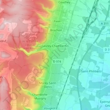
Name: Gevrey-Chambertin topographic map, elevation, terrain.
Average elevation: 1,089 ft
Minimum elevation: 682 ft
Maximum elevation: 1,801 ft
Make a donation
Gear up for your next adventure:
As an Amazon Associate, this site earns from qualifying purchases at no extra cost to you.
Other topographic maps
Click on a map to view its topography, its elevation and its terrain.
La Verrerie
France > Bourgogne-Franche-Comté > Côte-d'Or > Velars-sur-Ouche
Average elevation: 1,152 ft
Point d’eau du Leuzeu
France > Bourgogne-Franche-Comté > Côte-d'Or > Flavignerot
Average elevation: 1,611 ft
Make a donation
Gear up for your next adventure:
As an Amazon Associate, this site earns from qualifying purchases at no extra cost to you.