Geolocate

Yeronga topographic map

Click on the map to display elevation.

About this map

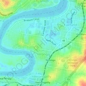
Name: Yeronga topographic map, elevation, terrain.

Location: Yeronga, Brisbane City, Queensland, 4104, Australia (-27.52324 152.99879 -27.50360 153.02852)

Average elevation: 52 ft

Minimum elevation: 13 ft

Maximum elevation: 154 ft

Other topographic maps

Click on a map to view its topography, its elevation and its terrain.

Willmington Park

Australia > Queensland > Brisbane City

Average elevation: 121 ft

Mount Gravatt

Australia > Queensland > Brisbane City

Average elevation: 230 ft

Ithaca

Australia > Queensland > Brisbane City > Ithaca

Average elevation: 102 ft

Gear up for your next adventure:

🛰️Handheld GPS Units - Professional satellite navigators for precise backcountry mapping
🌄Hiking Binoculars - Compact binoculars for scenic views and trail spotting
🔭Stargazing Telescopes - Perfect for camping in low-light pollution areas shown on maps
🧣Hiking Neck Gaiter - Multi‑use neck protection for outdoor weather
🧭Orienteering Set - Complete compass and map reading kit

As an Amazon Associate, this site earns from qualifying purchases at no extra cost to you.