
Cerro El Potosi topographic map
Interactive map
Click on the map to display elevation.
About this map
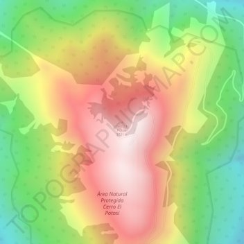
Name: Cerro El Potosi topographic map, elevation, terrain.
Location: Cerro El Potosi, Galeana, Nuevo León, Mexico (24.87401 -100.23378 24.87411 -100.23368)
Average elevation: 11,109 ft
Minimum elevation: 9,833 ft
Maximum elevation: 12,221 ft
Other topographic maps
Click on a map to view its topography, its elevation and its terrain.
Sierra Madre Oriental
Sierra Madre Oriental, Galeana, Nuevo León, Mexico
Average elevation: 10,079 ft
Monterrey
Mexico > Nuevo León > Monterrey
Monterrey, Nuevo León, 64010, Mexico
Average elevation: 2,470 ft
San Nicolás de los Garza
Mexico > Nuevo León > San Nicolás de los Garza
San Nicolás de los Garza, Nuevo León, 66443, Mexico
Average elevation: 1,916 ft
San Pedro Garza García
Mexico > Nuevo León > San Pedro Garza García
San Pedro Garza García, Nuevo León, 66210, Mexico
Average elevation: 2,618 ft
Guadalupe
Mexico > Nuevo León > Guadalupe
Guadalupe, Nuevo León, 67180, Mexico
Average elevation: 1,949 ft