
Belcourt topographic map
Interactive map
Click on the map to display elevation.
About this map
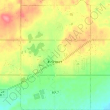
Name: Belcourt topographic map, elevation, terrain.
Location: Belcourt, Rolette County, North Dakota, 58316, United States (48.81990 -99.76685 48.86534 -99.72283)
Average elevation: 1,972 ft
Minimum elevation: 1,841 ft
Maximum elevation: 2,116 ft
Other topographic maps
Click on a map to view its topography, its elevation and its terrain.
Shell Valley
United States > North Dakota > Rolette County
Shell Valley, Shell Valley Township, Rolette County, North Dakota, United States
Average elevation: 1,765 ft
Turtle Mountain
United States > North Dakota > Rolette County
Turtle Mountain, Rolette County, North Dakota, 58329, United States
Average elevation: 2,313 ft