
Saint-Didier-sous-Riverie topographic map
Interactive map
Click on the map to display elevation.
About this map
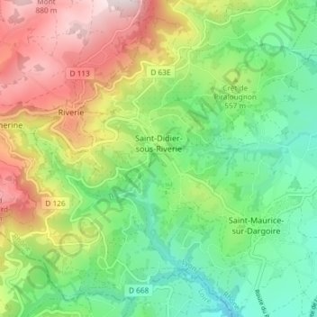
Name: Saint-Didier-sous-Riverie topographic map, elevation, terrain.
Average elevation: 1,752 ft
Minimum elevation: 1,017 ft
Maximum elevation: 2,930 ft
Other topographic maps
Click on a map to view its topography, its elevation and its terrain.
La Saulée
France > Auvergne-Rhône-Alpes > Rhône > Chabanière > Saint-Didier-sous-Riverie
La Saulée, Saint-Didier-sous-Riverie, Chabanière, Lyon, Rhône, Auvergne-Rhône-Alpes, Metropolitan France, 69440, France
Average elevation: 1,637 ft