
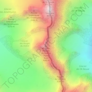
Aiguilles Rouges du Dolent - Pointe Kurz topographic map
Interactive map
Click on the map to display elevation.
About this map
Name: Aiguilles Rouges du Dolent - Pointe Kurz topographic map, elevation, terrain.
Average elevation: 10,128 ft
Minimum elevation: 8,271 ft
Maximum elevation: 12,510 ft
Other topographic maps
Click on a map to view its topography, its elevation and its terrain.
Monts Telliers
Monts Telliers, Orsières, Entremont, Vallese, 2303, Svizzera
Average elevation: 8,307 ft
Grand Golliat
Grand Golliat, Orsières, Entremont, Vallese, 2303, Svizzera
Average elevation: 8,924 ft
Grand Darray
Grand Darray, Orsières, Entremont, Vallese, 2303, Svizzera
Average elevation: 9,731 ft
Aiguilles Dorées
Aiguilles Dorées, Orsières, Entremont, Vallese, 2303, Svizzera
Average elevation: 10,220 ft