
Nea Peramos topographic map
Click on the map to display elevation.
About this map
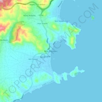
Name: Nea Peramos topographic map, elevation, terrain.
Average elevation: 135 ft
Minimum elevation: -3 ft
Maximum elevation: 1,273 ft
Other topographic maps
Click on a map to view its topography, its elevation and its terrain.
Στενά Νέστου
Greece > Macedonia and Thrace > Kavala Regional Unit > Paradisos
Average elevation: 1,473 ft