Geolocate

Lianga topographic map

Click on the map to display elevation.

About this map

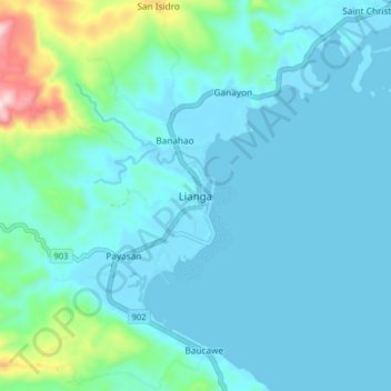
Name: Lianga topographic map, elevation, terrain.

Location: Lianga, Surigao del Sur, Caraga, 8307, Philippines (8.59303 126.05349 8.67303 126.13349)

Average elevation: 213 ft

Minimum elevation: 0 ft

Maximum elevation: 1,555 ft

Gear up for your next adventure:

🛡️Bear Spray Outdoor - Protection in bear country hikes
🥤Water Filter Bottle - All‑in‑one filter bottle for safe hydration
🦟Ultrasonic Repellers - Create a bug-free zone at your camp or rest stop
Camping Coffee Makers - Enjoy premium coffee at the summit or campsite
🪶Thermal Camp Blanket - Extra warmth for cold nights

As an Amazon Associate, this site earns from qualifying purchases at no extra cost to you.