
Забайкальск topographic map
Interactive map
Click on the map to display elevation.
About this map
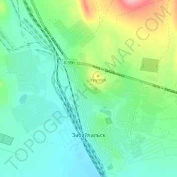
Name: Забайкальск topographic map, elevation, terrain.
Average elevation: 2,329 ft
Minimum elevation: 2,205 ft
Maximum elevation: 2,684 ft
Other topographic maps
Click on a map to view its topography, its elevation and its terrain.
Даурия
Россия > Забайкальский край > Забайкальский район
Даурия, Даурское сельское поселение, Забайкальский район, Забайкальский край, Дальневосточный федеральный округ, 674660, Россия
Average elevation: 2,215 ft