
Everöd topographic map
Interactive map
Click on the map to display elevation.
About this map
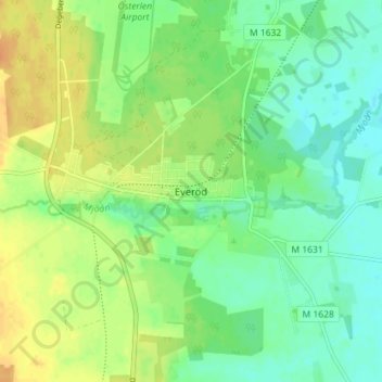
Name: Everöd topographic map, elevation, terrain.
Location: Everöd, Kristianstads kommun, Skåne län, 297 72, Zweden (55.87933 14.07767 55.91933 14.11767)
Average elevation: 72 ft
Minimum elevation: 26 ft
Maximum elevation: 128 ft
Other topographic maps
Click on a map to view its topography, its elevation and its terrain.
Vankiva gård
Vankiva gård, Vankiva, Hässleholms kommun, Skåne län, 281 95, Zweden
Average elevation: 190 ft
Kristianstad
Kristianstad, Kristianstads kommun, Skåne län, 291 30, Zweden
Average elevation: 20 ft