
Mensinghausen topographic map
Interactive map
Click on the map to display elevation.
About this map
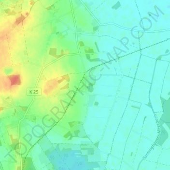
Name: Mensinghausen topographic map, elevation, terrain.
Average elevation: 138 ft
Minimum elevation: 98 ft
Maximum elevation: 236 ft
Other topographic maps
Click on a map to view its topography, its elevation and its terrain.
Hoysinghausen
Deutschland > Niedersachsen > Landkreis Nienburg/Weser > Uchte
Hoysinghausen, Uchte, Samtgemeinde Uchte, Landkreis Nienburg/Weser, Niedersachsen, Deutschland
Average elevation: 148 ft
Woltringhausen
Deutschland > Niedersachsen > Landkreis Nienburg/Weser > Uchte
Woltringhausen, Uchte, Samtgemeinde Uchte, Landkreis Nienburg/Weser, Niedersachsen, Deutschland
Average elevation: 125 ft
Lohhof
Deutschland > Niedersachsen > Landkreis Nienburg/Weser > Uchte
Lohhof, Uchte, Samtgemeinde Uchte, Landkreis Nienburg/Weser, Niedersachsen, Deutschland
Average elevation: 141 ft