
Sector 14 topographic map
Interactive map
Click on the map to display elevation.
About this map
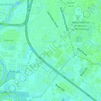
Name: Sector 14 topographic map, elevation, terrain.
Average elevation: 702 ft
Minimum elevation: 689 ft
Maximum elevation: 709 ft
Other topographic maps
Click on a map to view its topography, its elevation and its terrain.
Sector 17
India > Delhi > Dwarka Tehsil > Dwarka
Sector 17, Dwarka, Dwarka Tehsil, South West Delhi District, Delhi, India
Average elevation: 699 ft
Sector 9
India > Delhi > Dwarka Tehsil > Dwarka
Sector 9, Dwarka, Dwarka Tehsil, South West Delhi District, Delhi, 110077, India
Average elevation: 705 ft
Kakrola
India > Delhi > Dwarka Tehsil > Dwarka
Kakrola, Dwarka, Dwarka Tehsil, South West Delhi, Delhi, India
Average elevation: 699 ft
Sector 11
India > Delhi > Dwarka Tehsil > Dwarka
Sector 11, Dwarka, Dwarka Tehsil, South West Delhi District, Delhi, India
Average elevation: 702 ft
Sector 19
India > Delhi > Dwarka Tehsil > Dwarka
Sector 19, Dwarka, Dwarka Tehsil, South West Delhi District, Delhi, India
Average elevation: 699 ft