Geolocate

Odenwald topographic map

Click on the map to display elevation.

About this map

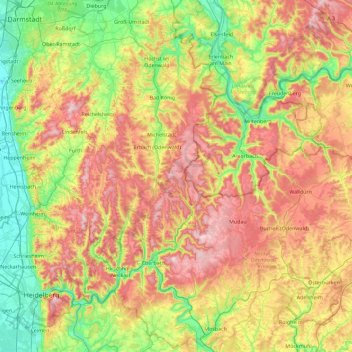
Name: Odenwald topographic map, elevation, terrain.

Location: Odenwald, Hesse, Germany (49.31254 8.61777 49.90398 9.44994)

Average elevation: 991 ft

Minimum elevation: 292 ft

Maximum elevation: 2,014 ft

Other topographic maps

Click on a map to view its topography, its elevation and its terrain.

Hohenfels

Germany > Hesse > Landkreis Marburg-Biedenkopf > Buchenau

Average elevation: 955 ft

Rhön

Germany > Hesse

The High Rhön (German: Hohe Rhön or Hochrhön) is that part of the central Rhön that lies in Hesse, Bavaria, and to a lesser extent in Thuringia; it covers an area of 344 km2 (132.8 sq mi) Landscape fact files by the BfN (c.f. section on Natural region division) and is up to 950.0 m (3,117 ft) and whose…

Average elevation: 1,342 ft

Darmstadt

Germany > Hesse

Average elevation: 495 ft

Schmitten

Germany > Hesse > Hochtaunuskreis > Schmitten

Average elevation: 1,752 ft

Diemelsee

Germany > Hesse

Average elevation: 1,365 ft

Traisa

Germany > Hesse > Landkreis Darmstadt-Dieburg > Mühltal > Traisa

Average elevation: 709 ft

Reichenbach

Germany > Hesse > Kreis Bergstraße > Lautertal

Average elevation: 1,030 ft

I-D

Germany > Hesse > Darmstadt

Average elevation: 564 ft

Lauterbach

Germany > Hesse > Vogelsbergkreis

Average elevation: 1,184 ft

Gear up for your next adventure:

🪶Compact Camp Shovel - Folding shovel for campsite tasks
🔦Powerful Headlamps - Ultra-bright hands-free lighting for night navigation
🪶Wildlife Field Guides - Learn animal tracking and species ID
🔪Outdoor Multitools - Essential survival tools for gear repair and field use
🧥Men's Rain Shells - Premium waterproof and breathable jackets for mountain weather

As an Amazon Associate, this site earns from qualifying purchases at no extra cost to you.