
Thank you for supporting this site ❤️
Make a donation
Make a donation
Gear up for your next adventure:
As an Amazon Associate, this site earns from qualifying purchases at no extra cost to you.
Laterns topographic map
Click on the map to display elevation.
Thank you for supporting this site ❤️
Make a donation
Make a donation
Gear up for your next adventure:
As an Amazon Associate, this site earns from qualifying purchases at no extra cost to you.
About this map
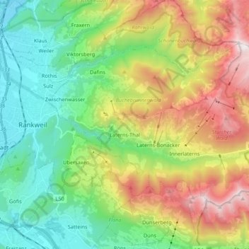
Name: Laterns topographic map, elevation, terrain.
Location: Laterns, Bezirk Feldkirch, Vorarlberg, Austria (47.23410 9.68693 47.30691 9.84989)
Average elevation: 3,225 ft
Minimum elevation: 1,381 ft
Maximum elevation: 6,549 ft
Thank you for supporting this site ❤️
Make a donation
Make a donation
Gear up for your next adventure:
As an Amazon Associate, this site earns from qualifying purchases at no extra cost to you.
Other topographic maps
Click on a map to view its topography, its elevation and its terrain.
Maria Grün
Austria > Vorarlberg > Bezirk Feldkirch > Marktgemeinde Frastanz
Average elevation: 1,870 ft