
Fermedo topographic map
Interactive map
Click on the map to display elevation.
About this map
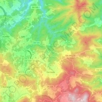
Name: Fermedo topographic map, elevation, terrain.
Location: Fermedo, Arouca, Aveiro, Portugal (40.94597 -8.43417 40.99272 -8.33604)
Average elevation: 951 ft
Minimum elevation: 157 ft
Maximum elevation: 1,949 ft
Other topographic maps
Click on a map to view its topography, its elevation and its terrain.
São Pedro Velho
São Pedro Velho, Arouca, Aveiro, 4540-013, Portugal
Average elevation: 3,018 ft