Geolocate

Lindberg topographic map

Click on the map to display elevation.

About this map

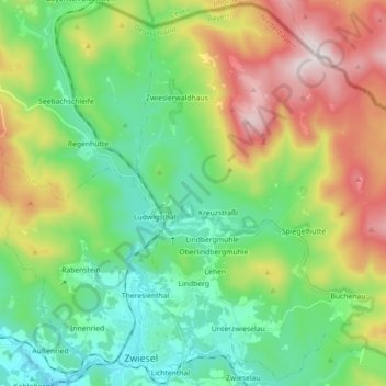
Name: Lindberg topographic map, elevation, terrain.

Location: Lindberg, Landkreis Regen, Bavaria, Germany (49.00562 13.22698 49.12049 13.40583)

Average elevation: 2,654 ft

Minimum elevation: 1,768 ft

Maximum elevation: 4,393 ft

Gear up for your next adventure:

📚Navigation Handbooks - Master the art of reading topographic maps and using a compass
📦Dry Bags Set - Waterproof storage for electronics and clothes
🛌Ultralight Sleeping Bags - Compact down bags for cold nights in the wilderness
🛠️Backpacking Tool Kit - Essential toolkit for outdoor repairs
🎒Hydration Pack - Hands‑free water reservoir for long hikes

As an Amazon Associate, this site earns from qualifying purchases at no extra cost to you.