
Águeda topographic map
Interactive map
Click on the map to display elevation.
About this map
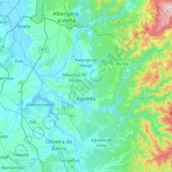
Name: Águeda topographic map, elevation, terrain.
Location: Águeda, Aveiro, Portugal (40.49591 -8.55815 40.69428 -8.24538)
Average elevation: 420 ft
Minimum elevation: 0 ft
Maximum elevation: 2,631 ft
Other topographic maps
Click on a map to view its topography, its elevation and its terrain.
Glória e Vera Cruz
Glória e Vera Cruz, Aveiro, Portugal
Average elevation: 13 ft
Albergaria-a-Velha
Albergaria-a-Velha, Albergaria-a-Velha e Valmaior, Albergaria-a-Velha, Aveiro, 3850-053, Portugal
Average elevation: 525 ft