
Castelo de Paiva topographic map
Interactive map
Click on the map to display elevation.
About this map
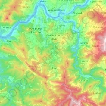
Name: Castelo de Paiva topographic map, elevation, terrain.
Location: Castelo de Paiva, Aveiro, Portugal (40.96226 -8.40092 41.08015 -8.22995)
Average elevation: 892 ft
Minimum elevation: 20 ft
Maximum elevation: 2,431 ft
Other topographic maps
Click on a map to view its topography, its elevation and its terrain.
Glória e Vera Cruz
Glória e Vera Cruz, Aveiro, Portugal
Average elevation: 13 ft
Albergaria-a-Velha
Albergaria-a-Velha, Albergaria-a-Velha e Valmaior, Albergaria-a-Velha, Aveiro, 3850-053, Portugal
Average elevation: 525 ft