
Valdredo topographic map
Interactive map
Click on the map to display elevation.
About this map
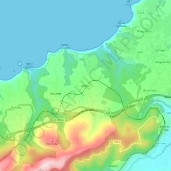
Name: Valdredo topographic map, elevation, terrain.
Location: Valdredo, Cudillero, Asturias, 33157, España (43.54843 -6.28012 43.58843 -6.24012)
Average elevation: 325 ft
Minimum elevation: 0 ft
Maximum elevation: 1,119 ft
Other topographic maps
Click on a map to view its topography, its elevation and its terrain.
San Pedro de la Ribera
San Pedro de la Ribera, Cudillero, Asturias, 33156, España
Average elevation: 230 ft
Castañeras
España > Asturias > Cudillero > Castañeras
Castañeras, Cudillero, Asturias, 33157, España
Average elevation: 381 ft
Pico las Cruces
Pico las Cruces, Cudillero, Asturias, España
Average elevation: 1,033 ft